Happy Birthday to the Manhattan Street Grid!

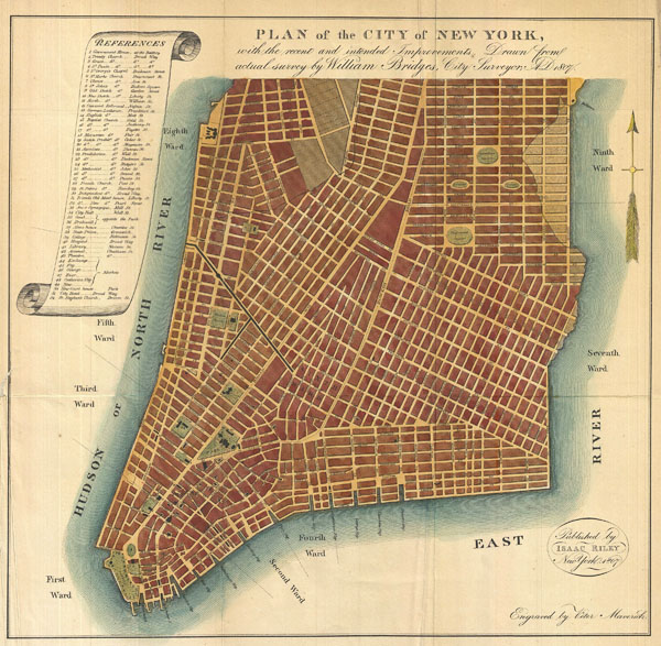
Happy birthday to the Manhattan Street Grid! Hailed by many historians as “the single most important document in New York City’s development,” the Commissioners’ Plan of 1811, better known as the original Manhattan Street Grid, was adopted on March 22, 1811! Well before Google Maps navigated our way through the city, the Grid was there to help us find our way.
The Grid was created in response to the New York City’s Common Council’s petition for a street plan to be developed above Houston Street. From 1790 to 1810, Manhattan’s population tripled and public health issues increased as a result. The growing population, the limited space available for housing and the threat of disease propelled city leaders to adopt an organized street plan for future growth and infrastructure needs. It should be noted, however, that public transportation was not considered in the grid’s planning process. Before the Street Grid, the topography of upper Manhattan was described as “a rural area of streams and hills populated by a patchwork of country estates, farms and small houses.” The Commissioners’ Plan avoided making changes to the streetscape of Greenwich Village and further downtown because most of the city’s population lived below North Street (Houston Street today). Stuyvesant Street was not affected by the plan because of its family legacy, its prominence in the area and the fact that it yielded high amounts of traffic. As a result, Stuyvesant Street is the only compass-tested east-to-west street in Manhattan.
Unfortunately, due to the street grid construction, a great deal of the city’s earliest buildings and architectural history were destroyed in the process. According to a report by historical geography expert Dr. Rose Redwood, an estimated 721 buildings had to be razed or moved due to the new streets designed in 1811. This shift in the city’s built environment created great debate among New Yorkers at the time. Clement Clarke Moore, author of ‘Twas the Night before Christmas’ actively protested the Commissioner’s Plan because it did not incorporate any protective measures for the natural environment of the island, and it also affected the parceling of his own property.

Despite certain resistance, the Commissioners’ Plan was adopted and construction was completed by the end of the 19th century. As a result, the Grid produced 11 major avenues and 155 cross-town streets that are still in use today.
There is no doubt that the Commissioner’s Plan of 1811 transformed Manhattan into the city we know and live in today. Fortunately, because the plan left most of the Greenwich Village street grid untouched, the neighborhood’s famously-tangled streetscape carries on the historical legacy of this city’s earliest settlers.
To get a better idea of how the grid affected the future development of Manhattan, stroll on over to Peretz Square where the winding streets of Greenwich Village connect to the Grid. And while you’re there, wish it a happy birthday… and many more to come.

One response to “Happy Birthday to the Manhattan Street Grid!”