
New York in Four Maps – Walking the Village of the Past
Earlier this week, photographer and NYC tour guide David Schmidlapp took us on a meander through the East Village using four old, beautiful maps of New York City as part of a program for GVSHP. Armed with a copy of each map, we explored the present-day streets imagining the streams, farmlands, docks, and buildings as they were when these maps were made. The four maps, in chronological order, are:
* The 1767 Ratzer Map
* The 1811 Commissioner’s Plan Map
* The 1820 Randel Composite Farm Map
* The 1874 Viele Topographical Map

Read on to explore and learn more about these incredible maps and their cartographers.
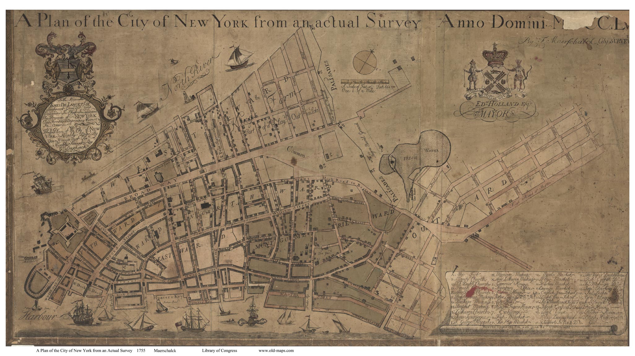
Ratzer Map: 1766-67

This map was created by Bernard Ratzer of the British Royal American Regiment. It was made at a time of increased political and civil unrest in New York and in colonial America generally. The British knew that a good, accurate map would help in all their endeavors, military and otherwise, as the Revolutionary War loomed on the horizon.
Bernard Ratzer was a lieutenant in the 60th Regiment. He was stationed in New York and was an engineer. His first foray into cartography was in the Passamaquoddy Bay in Maine in 1756. Otherwise, there’s little information available about Ratzer himself or his military service. Ratzer traversed Manhattan and Brooklyn in 1766-67, creating two maps. The first, because of a typesetter’s mistake, was called the “Ratzen” map. The second, the Ratzer map, is the larger of the two. The map was published in 1770. It expanded considerably on the maps that the British were using at the time, the Bradford Map of 1730 and the Maerschalck Map of 1755.
Both informative and beautiful, the map is dotted with trees and topographical markers. The five streams that dipped into the East Village are visible, and the area is described as “Salt Meadows.” The Bowery Lane is prominent as the largest, most central road in New York. Small plots, fields, and farms radiate out from the Bowery, with the names of the landowners indicated in each area. The Stuyvesant family is well represented as landowners, but not much else was around.
Christie’s auctioned a 1776 print of the map, estimating its worth to be between $3,000 and $4,000. The map sold for $106,250.
The best place I found to view the map online is here – you can zoom in on any segment and see the incredible details. Learn more about the map here.
1811 Plan Map of Manhattan

As the Ratzer Map makes clear, the streets of lower Manhattan, as they’d developed under first Dutch and then British rule, were a mixture of country lanes, short streets and Native American and animal trails, all shaped by haphazard history, happenstance and property ownership, without any overarching order. However, the city was growing exponentially and quickly.
Beginning in 1803, the City’s Common Council started to take interest in and ownership of the city’s streets, which previously had been the domain of property owners. In 1809, the Council was running into land use and ownership difficulties. They conceived of the grid system we know so well today, and the 1811 Plan Map is the first map to lay out that plan.
The Common Council appointed statesman and founding father Gouverneur Morris; surveyor, lawyer, and former Senator John Rutherfurd; and New York State Surveyor General Simeon De Witt for the task. Their job: “laying out Streets… in such a manner as to unite regularity and order with the public convenience and benefit and in particular to promote the health of the City…”
The grid – with its numerical streets and avenues – gave New York City an easy design that would be navigable and clear. Not everything from the plan made it into reality, and so this map must be read not as how the city was, but rather as the aspirations of these government-commissioned leaders. The most striking difference is that the grid layout does not include Central Park, but rather some smaller gardens and parks scattered around the grid. The East Village includes a Market Place which does not exist in the Village as we know it. St. Mark’s Church is listed, and the Stuyvesants are again well represented. In this map, when Broad Way meets Union Place, it turns into Bloomingdale Street as it heads north – this also did not materialize, though Union Square’s representation appears to be a meeting spot between plots and streets owned by a number of well-known figures like Arden, Tompkins, and Dunham.
The 1811 plan is also on the Museum of the City of New York’s site in an Interactive format. View it online here.

Randel Composite Map: 1820

Between 1818 and 1820, John Randel, Jr. created a collection of 92 watercolor maps that vividly illustrate the properties, old roads, and major features of pre-grid Manhattan – superimposed with the future grid of streets proposed in the 1811 plan. The map also shows topographical markers – using a set of metal stakes, Randel was able to determine elevations of the land he was surveying. Drawn at a scale of 100 feet to 1 inch, the Randel Farm Maps provide a detailed picture of Manhattan’s hills, streams, beaches, ponds, wetlands, rock formations, and cliffs before its transformation.
Randel’s job was to implement the new grid plan, which was met with much pushback from landowners. According to this New York Times article:
Beginning in 1808, Randel and his colleagues were pelted with artichokes and cabbages; arrested by the sheriff for trespassing (and often bailed out by Richard Varick, a former mayor); sued for damages after pruning trees; and attacked by dogs sicced on them by property owners irate at the prospect of streets’ being plowed through their properties (“many of whose descendants have been made rich thereby,” Randel noted later).
Randel was born in Albany around 1787. He apprenticed with Simeon De Witt, surveyor general of New York State and one of the three street commissioners. “Randel was as meticulous in his accounting as in his surveying — his notebooks include a $12 invoice for a horse.” Randel went on to serve as chief engineer for the Chesapeake and Delaware Canal Company, though he was fired from that job. Later, Randel was also involved in the planning for the first elevated subway.
The southernmost point of this map is “North Street,” which we now know as Houston Street. The Village in this map is much more developed, and more of the names we continue to recognize show up: the Stuyvesants yes, also the Astors, Eliza Fish and Judith Winthrop – perhaps the first women listed on a New York map – and many others. St. Mark’s Church and its now-gone cemetery are drawn in greater detail. And a street called Stuyvesant Street bisects the Village.

The Museum of the City of New York and the Office of the Manhattan Borough President worked together to digitize this map in two ways: each of the 92 sheets are digitized individually, and an interactive, composite map.
Viele Map 1874

The full title of this map is the Sanitary & Topographical Map of the City and Island of New York Prepared for the Council of Hygiene and Public Health of the Citizens Association Under the Direction of Egbert L. Viele, Topographical Engineer. That’s a lot of words, but it also explains the purpose of the map itself. Manhattan had been a very watery place – remember those five streams in the East Village first recorded on the Ratzer Map? This map also includes Minetta Stream, running under Washington Square, along with countless canals, swamps, rivers, ditches, ponds, meadows, and drainage basins.
Cartographer and civil engineer Colonel Egbert Ludovicus Viele was born in 1825 in Saratoga County. Viele graduated from West Point, and entered the competition to design Central Park, but lost to Frederick Law Olmsted. He worked as the park’s chief engineer in 1856 and engineer of Prospect Park in Brooklyn in 1860, and was involved in planning for the subway system. Viele knew that natural drainage was of vital importance both for city planning purposes and for public health. Viele wrote: “The Sanitary condition of any city or district or country is intimately connected with its proper drainage . . . that any inquiry into causes or remedies for sanitary evils . . . shall be based upon a thorough knowledge of the topography of the island.”
Viele’s Map continues to be used by city officials, utilities, architects, and subway planners who need to know whether they’ll hit water when they dig below our modern streets. Paul Starrett, who built the Empire State Building and Stuyvesant Town, used this map to prepare estimates of construction costs.

This map also shows an important piece of East Village and New York history by including the dry dock district along the East Village waterfront. The docks of the East Village are shown in orange and reflect the part of the East Village that was built out from the original shore into landfill and docks. Those docks served river traffic and industry to the island, as the farmland and five streams of the East Village were built over and developed. The Bowery continues to bisect the Village most prominently on its way up to Union Square.
Viele’s Map can be seen in detail online here.
I live at the James Brown House on Spring St., home of the Ear Inn pub.
We had our 200th anniversary last year, tho the date of 1817 was when the City took over the neighborhood and plowed the grid onto the Village of Greenwich. Our house is older but there is no deed to say when built. We have search various archives but have not found any legal proceedings that validate the expansion of NYC, just City Council records authorizing road construction. Is this a case of adverse occupation?
Do you know any scholar or source to find out more?
Thanks
Rip Hayman
914-263-6716